
Dunbeath Castle, Caithness. Imagine driving along a thickly wooded driveway, past stone pillars and an ivy-clad gatehouse.
It seems as if you must have taken a wrong turn, for the drive just stretches deeper and deeper into the wood. Finally, at the end,
you spot it, and immediately your breath is swept away. That was my first impression of Dunbeath Castle, and it is the very reason I
modeled my fictional "Castle Wrath" after Dunbeath in my novel, The Secret Gift. Pristine white-washed walls topped
by romantic turrets, and perched over a swirling sea, Dunbeath has stood since the 14th century, added to and renovated
time and again throughout the 19th century. This castle has always been well cared for, a tradition that continues today with the current laird.
Privately owned, it is not open to the public, but if you'd like a true treat, there are several holiday rental properties available on the Dunbeath Estate. It is accommodation I highly recommend both
for exploring the estate and nearby village of Dunbeath, as well as all of the Northern Highlands.
 |

 Strathnaver, Sutherland. A long lush valley called Strathnaver runs for some fifteen miles south from
northern coast of Scotland. It was known by its Gaelic-speaking inhabitants as Dúthaic 'ic Aoidh
— "MacKay's Country," and at one time, Strathnaver was heavily populated with clansmen of the Mackay.
For generations, the land was defended and held by the Mackay chief, a clan descended from the royal house of Moray...
until the early 1800's when the then Mackay chief and 7th Lord Reay gambled himself into debt, selling
his clan's heritage, and the entire estate to the nearby Sutherlands for Ł300,000.
The move made the then Countess of Sutherland the largest single landlord in Britain. Not, however, for long.
Strathnaver, Sutherland. A long lush valley called Strathnaver runs for some fifteen miles south from
northern coast of Scotland. It was known by its Gaelic-speaking inhabitants as Dúthaic 'ic Aoidh
— "MacKay's Country," and at one time, Strathnaver was heavily populated with clansmen of the Mackay.
For generations, the land was defended and held by the Mackay chief, a clan descended from the royal house of Moray...
until the early 1800's when the then Mackay chief and 7th Lord Reay gambled himself into debt, selling
his clan's heritage, and the entire estate to the nearby Sutherlands for Ł300,000.
The move made the then Countess of Sutherland the largest single landlord in Britain. Not, however, for long.
 From 1807 on, the Sutherland estate decided that there was more money to be made from grazing sheep than accommodating
subsistence crofters, and systematically cleared the land of its inhabitants. Clearing meant burning their homes down around them,
removing them by force if need be. Many of the crofters died, either from the brutal and shameful tactics of the Sutherland factor,
Patrick Sellar, or from being left to the harshness of the elements without shelter or food. In one fell swoop, people who had lived
for generations, working the land and fighting for their chief, vanished. In their place came sheep to graze upon the graves of their ancestors.
The Countess of Sutherland used the profits she gained by turning her attentions to remodeling the family keep, expanding it into a 189 room
French-style castle called Dunrobin. To this day, vast tracts of the county of Sutherland still bear the ruins of the once populous crofting villages, and
the echoes of the lives that had been forever changed. The land is still owned by the current Countess of Sutherland.
From 1807 on, the Sutherland estate decided that there was more money to be made from grazing sheep than accommodating
subsistence crofters, and systematically cleared the land of its inhabitants. Clearing meant burning their homes down around them,
removing them by force if need be. Many of the crofters died, either from the brutal and shameful tactics of the Sutherland factor,
Patrick Sellar, or from being left to the harshness of the elements without shelter or food. In one fell swoop, people who had lived
for generations, working the land and fighting for their chief, vanished. In their place came sheep to graze upon the graves of their ancestors.
The Countess of Sutherland used the profits she gained by turning her attentions to remodeling the family keep, expanding it into a 189 room
French-style castle called Dunrobin. To this day, vast tracts of the county of Sutherland still bear the ruins of the once populous crofting villages, and
the echoes of the lives that had been forever changed. The land is still owned by the current Countess of Sutherland.
|
 Ullapool, Northwest Highlands. Nestled on the shores of Loch Broom on Scotland's northwestern coast, the lands that comprise Ullapool
changed hands with the changing fortunes of Highland nobility throughout the Middle Ages, belonging in turn to MacLeod, Mackay of Strathnaver,
the Earl of Ross and again to Macleod of Lewis. It was disputed territory until the early 17th century when a key marriage resolved the issue.
The land then became the westernmost extremity of the Mackenzie estates. There are ruins dating back to the Picts and Viking settlers,
but Ullapool itself is a fairly recently created town, established in 1788 as a herring port. Fishing has been
the main industry ever since. Today, Ullapool is a picturesque fishing village with wide streets and white-washed cottages, street signs written in
Gaelic and (yes!) even palm trees. There is much on offer here to the Highland tourist with a variety of restaurants, shops, and attractions. You can take a ferry to the Hebridean isle of Stornoway or a boat cruise along Loch Broom. You are easily within reach of Inverness,
the isle of Skye and nearby Highland villages on winding single track roads that offer the best scenery of the Highlands.
Ullapool, Northwest Highlands. Nestled on the shores of Loch Broom on Scotland's northwestern coast, the lands that comprise Ullapool
changed hands with the changing fortunes of Highland nobility throughout the Middle Ages, belonging in turn to MacLeod, Mackay of Strathnaver,
the Earl of Ross and again to Macleod of Lewis. It was disputed territory until the early 17th century when a key marriage resolved the issue.
The land then became the westernmost extremity of the Mackenzie estates. There are ruins dating back to the Picts and Viking settlers,
but Ullapool itself is a fairly recently created town, established in 1788 as a herring port. Fishing has been
the main industry ever since. Today, Ullapool is a picturesque fishing village with wide streets and white-washed cottages, street signs written in
Gaelic and (yes!) even palm trees. There is much on offer here to the Highland tourist with a variety of restaurants, shops, and attractions. You can take a ferry to the Hebridean isle of Stornoway or a boat cruise along Loch Broom. You are easily within reach of Inverness,
the isle of Skye and nearby Highland villages on winding single track roads that offer the best scenery of the Highlands.
 Ardvreck Castle, Northwest Highlands.
Just north of Ullapool on the A837 stands the ruins of this 16th century three story castle. The keep stands on the shore of Loch Assynt
on what is nearly an island. This was the home to the MacLeod of Assynt, and according to legend, the castle was built by the devil in exchange
for MacLeod's eldest daughter. When the castle was completed, MacLeod refused to hand over his daughter (or rather he couldn't—read below), so the devil put a curse on him.
It is said the Marquise of Montrose was held prisoner here before being sent to Edinburgh for execution
after his capture in 1650. MacLeod, it is further said, was responsible for his capture, for though he had Royalist sympathies and was considered
a friend of Montrose`s father, MacLeod was in financial difficulty and the lure of 20,000 pounds was too much for him. He betrayed the custom of
"Highland hospitality," and imprisoned the marquise.
MacLeod`s fate was not much better. He never saw much of the money but received a large supply of rotten oatmeal instead.
MacLeod owed money to the Seaforth MacKenzies who laid siege to the castle and claimed it for themselves after obtaining letters of fire and sword against the MacLeods.
The MacKenzies then build a large dwelling house, Calda House, also known as Edderchalder, near the castle, the ruins of which yet remain.
During the Highland clearances, when the people of the land were removed to make way for sheep, the castle fell into disrepair.
Privately owned today, the castle is freely accessible at all times and a collection box asks simply for donations to keep the ruins so freely open (a worthy cause).
The castle is said to have two ghosts, one, a tall man dressed in grey said to be related to the betrayal of Montrose. The other is the ghost of the daughter of the Macleod
who rather than submit to wedding the Devil her father had promised her to, threw herself from the top of the castle and was killed.
Ardvreck Castle, Northwest Highlands.
Just north of Ullapool on the A837 stands the ruins of this 16th century three story castle. The keep stands on the shore of Loch Assynt
on what is nearly an island. This was the home to the MacLeod of Assynt, and according to legend, the castle was built by the devil in exchange
for MacLeod's eldest daughter. When the castle was completed, MacLeod refused to hand over his daughter (or rather he couldn't—read below), so the devil put a curse on him.
It is said the Marquise of Montrose was held prisoner here before being sent to Edinburgh for execution
after his capture in 1650. MacLeod, it is further said, was responsible for his capture, for though he had Royalist sympathies and was considered
a friend of Montrose`s father, MacLeod was in financial difficulty and the lure of 20,000 pounds was too much for him. He betrayed the custom of
"Highland hospitality," and imprisoned the marquise.
MacLeod`s fate was not much better. He never saw much of the money but received a large supply of rotten oatmeal instead.
MacLeod owed money to the Seaforth MacKenzies who laid siege to the castle and claimed it for themselves after obtaining letters of fire and sword against the MacLeods.
The MacKenzies then build a large dwelling house, Calda House, also known as Edderchalder, near the castle, the ruins of which yet remain.
During the Highland clearances, when the people of the land were removed to make way for sheep, the castle fell into disrepair.
Privately owned today, the castle is freely accessible at all times and a collection box asks simply for donations to keep the ruins so freely open (a worthy cause).
The castle is said to have two ghosts, one, a tall man dressed in grey said to be related to the betrayal of Montrose. The other is the ghost of the daughter of the Macleod
who rather than submit to wedding the Devil her father had promised her to, threw herself from the top of the castle and was killed.
|

Whaligoe Steps, Caithness. Just south of the town of Wick on Scotland's most northeasterly coast lies a most spectacular creation.
'The Whaligoe Steps' are a sea stairway with 365 steps—one for each day of the year—that descend
to what was more than a hundred years ago a landing place for fishing boats. Some of the steps date from the 17th century,
and the staircase was once used by fisherwomen to haul up the creels of herring landed at the harbour beneath. Though a popular attraction today,
they are notoriously difficult to find as the steps are not signposted on the main road, so you'll have to do your research beforehand for directions
on how to locate them. (Here's a hint: they are located near the village of Ulbster just off the A99.) The journey to find them, however, is well worth the effort.
At the bottom of the steps is a 'harbor' naturally formed between two spectacular sea cliffs. The day we visited, the weather was fierce with wind
and the sea was raging against the rocks. I could not imagine anyone managing to steer a vessel safely through. Sea birds such as oyster catchers and
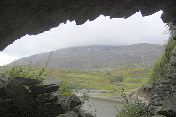
terns nest in the cliffsides and circle on the wind down to the water. On a clear day, it would be the perfect spot for a picnic, and there is also a sea cave that is a treat to explore.


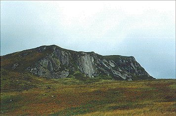
Hill O' Many Stanes, Caithness. A few miles further south of Wick on the A99 is a curious hillside peppered with
perfectly aligned rows of over 200 ancient stones, called fittingly enough, the Hill O' Many Stanes. There is evidence to suggest that there may originally have been over 600 stones
and the site is said to have been set up about 1900 BC.
The stones are small, less than 1 meter high and mostly only a few inches wide. They are set on a south-facing slope, below a cairn.
The two most common explanations for the formation are first, that it may have had an astronomical function, and that the stones could have been formed in its fan-shaped grid for the purpose of
observing the movement of the moon.
Local tradition, however, claims that the hill marks the site of a battle between two rival clans, the Keiths and the Gunns. The Gunns, they say, won the battle and set up a memorial to the day by
burying the dead of both clans in rows, marking the head of each dead warrior with a stone. A bit of a more romantic explanation than the first, if you'd like to explore it, unlike the Whaligoe Steps, the way to the 'Stanes' is clearly signposted on the main road.

John O' Groats, Caithness. Look at the top right corner on any map of Scotland and you'll see the village of
John O'Groats, one end of a 874 mile trek commonly called the End to End (The other 'end' lies at Land's End in Cornwall, England and the journey
covers the whole of the U.K.) In this village, a mound and flag pole near the John O'Groats House Hotel mark the site where Jan de Groot, a Dutchman, built
his famous house in the 15th century. In 1496 King James IV granted De Groot the ferry franchise between the harbour here and the Orkneys. The coin for this
journey became known as the 'groat,' hence the name of the village. A ferry still runs from this spot northward to the Orkney Isles today.
Take the marked walk along the shore to Duncansby Head and you'll be treated to spectacular sea cliffs and the sea stacks formed by the natural
ferocity of the Pentland Firth. The walk will guide you past large sea-bird colonies where you will be able to see guillemots, kittiwakes, fulmars, razorbills and puffins among many other bird species.

Two miles off the shore to the north (and barely visible in this photo), lies the now lonely Isle of Stoma. Although once a busy inhabited island, it is now deserted. The last family left the island in 1962,
and deserted croft houses can still be seen from the mainland along its landscape. During the summer weekends, you might take a ferry trip from John O' Groats to the island to spend the day viewing the history still evident here, the seals, and the bird-life.
On the west side of the island you can find the remains of a reputed pirates lair, a pillar of rock surrounded by the sea.
Further along the grass and heather braes is the Devil's Punch Bowl or Big Gloup, consisting of a natural hollow in the ground with a ledge running above sea level.
This channel can be sailed by small boats and islanders once hid their whiskey from the excise men in it.
|
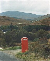
 Scotland's Northern Coast. If you drive the A836 along Scotland's northern coast, you'll
encounter a myriad of tiny villages and sandy, unspoilt beaches. The people here are wonderfully friendly,
as evidenced by the kindly mechanic in Reay who helped us with an unexpected flat tire and refused to take anything
in payment, as well as the lovely couple who own Elizabeth's cafe and craft shop in Bettyhill (the food here is excellent), who helped us find
a nearby garage who (thankfully!) had a replacement tire. This was once the country of the Mackay (the clan featured in my book,
The Adventurer) and this wild and
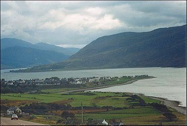
remote landscape provided the perfect atmosphere for the story. The largest village in this part of the country is Tongue,
the name stemming from "tunga" or the tongue of land which juts out into the kyle off the sea.
Tongue is an attractive village with imposing stone buildings. Among these are the Tongue Hotel, a former hunting lodge. Views from the village are dominated by the bulk of Ben Loyal to the south and by Caisteal Bharraigh and the truly beautiful Kyle of Tongue to the west.
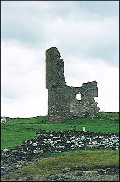
The remains of Caisteal Bharraigh, or Castle Varrich, can be seen here today, a small tower spectacularly
located on the summit of a bluff dominating the Kyle of Tongue.
A footpath leads to it for exploring, and although the origins of the castle are unclear, some believe it could be the "Beruvik" mentioned in the Norse Orkneyinga Saga.
Others believe it was built as recently as the 1500s by the Mackay clan and was their clan seat before the
they moved to the newer tower house, the House of Tongue, which is located a little north of today's village,
when they dominated this part of Sutherland. The Mackay clan, Lords of Reay, had a large hand in
the settlement of this village and the surrounding lands all the way to Cape Wrath, Scotland's most northwesterly point.
Scotland's Northern Coast. If you drive the A836 along Scotland's northern coast, you'll
encounter a myriad of tiny villages and sandy, unspoilt beaches. The people here are wonderfully friendly,
as evidenced by the kindly mechanic in Reay who helped us with an unexpected flat tire and refused to take anything
in payment, as well as the lovely couple who own Elizabeth's cafe and craft shop in Bettyhill (the food here is excellent), who helped us find
a nearby garage who (thankfully!) had a replacement tire. This was once the country of the Mackay (the clan featured in my book,
The Adventurer) and this wild and
remote landscape provided the perfect atmosphere for the story. The largest village in this part of the country is Tongue,
the name stemming from "tunga" or the tongue of land which juts out into the kyle off the sea.
Tongue is an attractive village with imposing stone buildings. Among these are the Tongue Hotel, a former hunting lodge. Views from the village are dominated by the bulk of Ben Loyal to the south and by Caisteal Bharraigh and the truly beautiful Kyle of Tongue to the west.
The remains of Caisteal Bharraigh, or Castle Varrich, can be seen here today, a small tower spectacularly
located on the summit of a bluff dominating the Kyle of Tongue.
A footpath leads to it for exploring, and although the origins of the castle are unclear, some believe it could be the "Beruvik" mentioned in the Norse Orkneyinga Saga.
Others believe it was built as recently as the 1500s by the Mackay clan and was their clan seat before the
they moved to the newer tower house, the House of Tongue, which is located a little north of today's village,
when they dominated this part of Sutherland. The Mackay clan, Lords of Reay, had a large hand in
the settlement of this village and the surrounding lands all the way to Cape Wrath, Scotland's most northwesterly point.

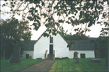
A visit to the small church at Tongue, St. Andrew's, will tell much of the clan's connection to the village; many of the clan chiefs are
buried here. St. Andrew's Church is one of the most historic Churches in the North. It is often referred to as "The Church of the Mackays". Others speak of it as "The Little White Church".
It was the chief of the Mackay who helped fund the rebuilding of the church in 1724 on the site of two earlier churches.
Generations of Mackay chiefs worshipped here beneath an elaborate carved wooden gallery that is today housed in a Scottish museum.
But perhaps Tongue's most significant moment in history came back in 1746 when the ship Hazard, carrying gold and arms for the Bonnie Prince and his Jacobite rebels,
fled into the Kyle of Tongue to evade a Royal Navy frigate. It unfortunately grounded itself on the shallow sands of the kyle and the crew took the gold
ashore in an effort to carry it overland to its 'bonnie' intended. They were captured at Loch Hakel, near the southern end of the Kyle of Tongue. The gold, legends says,
was thrown into the loch and most of it was never recovered. How true is this? What adds significance to the story is that at various times throughout the centuries since, gold pieces
have been found embedded in the hooves of cattle grazing near the loch's shore. Hmm...

|
Please any comments or suggestions.
Copyright © 1996-2009, and beyond by Jaclyn Reding and
Webscribbler Designs. All Rights Reserved.
|